/eh/2025-01-08/173633966714069467/picture.png)

/eh/2024-12-24/173503345348979036/Favorite-Icon.png)
/eh/2025-07-08/1751962110204480194/picture.png)
/eh/2025-06-21/1750485478958537574/countryInfoIcon.png)
/eh/2025-06-21/1750485741321434291/Hi-Sign-in-My-Nihao.png)
/eh/2025-06-21/1750485837193896318/cart.png)
/eh/2025-06-21/1750485968202533847/cart.png)
/eh/2025-04-17/1744862476612819675/hot-img.png)
/eh/2025-11-07/1762504524550532584/header-icon.jpg)
/eh/2025-07-07/1751875582852206790/header-icon.png)
/eh/2025-07-07/1751875587886277738/header-icon.png)

Best in 7 days



Shopping security
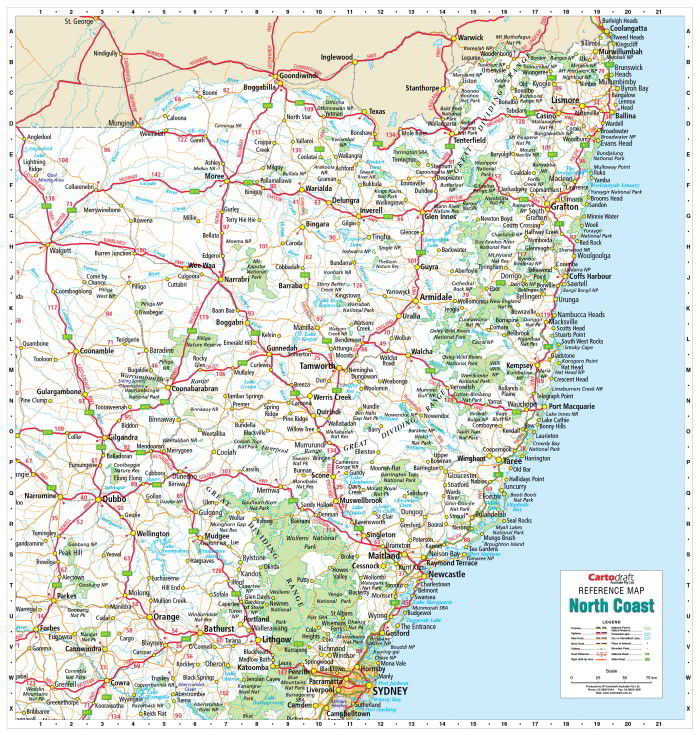
The North Coast New South Wales Reference Map is a clear, durable, and professional wall map ideal for offices, classrooms, or home use. Covering from Coolangatta in the northeast down to Campbelltown in the southeast, and west as far as Quambone, it provides a detailed and easy-to-read overview of this diverse region.
Cities, towns, major and minor roads, railways, waterways, and national parks are all shown, making this a versatile tool for planning, logistics, education, or display.
Comprehensive coverage — Coolangatta to Campbelltown, west to Quambone
Detailed cartography — Cities, towns, roads, railways, waterways, and parks clearly marked
Practical reference — Great for travel, business planning, or teaching
Large-format wall map — 1 × 1.05 m size ensures excellent readability
Display-ready — Supplied laminated with timber hang rails and hanging cord
Laminated (True Encapsulation):
Sealed in 2 × 80-micron gloss laminate, edge-sealed for durability
Waterproof, tear-resistant, and wipe-clean surface
Protects against everyday wear and stains
Interactive Surface:
Use whiteboard markers to highlight routes or add notes — wipes clean easily
Apply map dots to track locations without leaving permanent marks
Timber Hang Rails:
Fitted top and bottom with natural timber rails, lacquered for protection
Includes a strong top cord so the map can hang securely from a single wall hook
Australian Made:
Printed locally using pigment-based, fade-resistant inks for sharp detail and colour stability.
⚠️ This is a print-on-demand product. Please allow up to 10 working days for delivery, as hang rails are custom-fitted by our framer.
1000 mm × 1050 mm (39.3" × 41.3")
Orientation: Square-format portrait
| Attribute | Details |
|---|---|
| Title | North Coast NSW Reference Map |
| Coverage | Coolangatta (NE) to Campbelltown (SE), west to Quambone |
| Features | Cities, towns, major & minor roads, railways, waterways, national parks |
| Print Size | 1000 mm × 1050 mm |
| Format | Laminated + Timber Hang Rails |
| Laminate | 2 × 80-micron gloss (true encapsulation) |
| Hang Rails | Natural timber, lacquered; with top hanging cord |
| Inks | Pigment-based, fade-resistant |
| Origin | Printed in Australia |
🏢 Offices & businesses — A professional wall reference for planning and logistics
🏠 Households & travellers — A practical planning map for the North Coast
🚛 Service providers — Durable, interactive map for daily use
🎓 Schools & libraries — A clear, easy-to-read teaching and display map
Every laminated wall map is printed and finished locally in Australia, using fade-resistant inks and archival materials. Each copy is hand-checked, custom-finished with hang rails, and professionally packed so it arrives ready to hang.
🛒 Order your North Coast NSW Laminated Wall Map with Hang Rails today — a durable, display-ready reference for one of the state’s most important regions.
Ships within 48 hours · Estimated delivery Jul 14 - Jul 19
US$40
Get nowSign up to your membership to get coupons up to
15%
Get nowOpportunity to enjoy order discount up to 15% off
Top-Converting Item to Boost Your Average Order


